


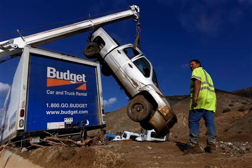
LOS ANGELES (AP) — Crews digging vehicles out from under tons of mud that clogged Southern California roadways during flash flooding three days ago were dealing with another round of rain on Sunday.
A drizzle blanketed the region, but forecasters said there’s little chance of thunderstorms like those that unleashed debris flows Thursday, damaging dozens of homes and trapping hundreds of cars on highways and roads.
“When it started raining again, we all held our breath,” said California Highway Patrol Officer Justin Foraker. “But luckily the rain has been light so far.”
At least 30 vehicles remained stuck in now-hardened mud along State Route 58 in Kern County, according to the California Department of Transportation. Officials hope to have the mess cleared and the lanes reopened by Thursday at the latest.
“We’re being conservative. We hope to reopen even earlier, but a lot of work remains,” said Caltrans spokeswoman Florene Trainor.
Geologists were checking the stability of nearby hillsides and workers were clearing culverts and drainage pipes, she said.
More than 100 cars, buses, RVs and semi-trucks were trapped on State Route 58 in last week’s flooding. There were no reports of injuries.
Hundreds of cars also were stuck on Interstate 5, a major artery, but those vehicles were cleared and the freeway reopened by late Friday.
Homeowners in northern Los Angeles County communities were spending their weekend digging mud out of their houses.
Kerjon Lee, a spokesman for Los Angeles County Public Works, said Saturday that more than 30 pieces of heavy equipment were on the ground in the small mountain communities of Elizabeth Lake and Lake Hughes in Leona Valley, about 40 miles north of Los Angeles.
He said in that area alone, crews need to clear out 20,000 dump trucks worth of dirt, which could take months. The dirt eventually will be used to backfill eroded canyons.
Meanwhile, Lee said at least one of the homes in the area is considered a total loss after flooding ripped it from its foundation. Crews were continuing to assess homes in the area, and Lee said the number of those destroyed could rise.
Gary and Gina Hartle, who own a 70-acre horse ranch in Lake Hughes, said they have so much work to restore their property, they have no idea how long it will take.
“Our property is 75 percent devastated,” Gina Hartle, 54, told The Associated Press as she surveyed the damage. “We can’t access our homes too well right now because everything is washed out.”
She said the two homes on the land seemed like they were OK, but that one of the homes was without water because of an inundated pump, and their 20-foot trailer is nowhere in sight.
“It either got buried or it’s downriver,” Hartle said.
__
Associated Press writer Christopher Weber contributed.
Copyright 2015 The Associated Press. All rights reserved. This material may not be published, broadcast, rewritten or redistributed.







My spouse and I have spent quite a lot of time on California Highway 58, which is one of the main connecting roads between Barstow, Mojave, and Bakersfield – and the usual route when one needs to travel from I-5 over to I-15 (Las Vegas corridor) and I-40 (Flagstaff, Albuquerque and points east).
The thing I’m wondering is whether these mud-slides have impacted the railroad corridors through Tehachapi and Mojave… a LOT of cargo goes through those routes.
I can’t speak for the Tehachapi route, but my friend is the foreman of the maintenance crew that cares for about half of the Feather River Canyon (formerly Western Pacific, now UP).
Mudslides from the burns in the canyon and above are pretty much part of the weather. Heavy rain, worse rain on wet heavy snow, are both regular occurences, and down comes the mud.
Last summer the Chips Fire burned through the standing dead from the 1997 fire (not salvage logged, due in my opinion to the failure of the Sierra Club, in particular, to participate in the Quincy Library Group process); the fire went vortex, vaporizing organics down to mineral soil.
All that is holding really spectacular debris flows is the grass that has grown during the drought winter of 2014/15. Yesterday’s little deluge may support a little more growth (the ground in Portola is greening nicely), but those grass shoots are nothing in the face of a big Pacific storm.
The thing about the railroad is, they can predict the storm and the mudflow, and will be in with heavy equipment as soon as it is safe.
This route is the designated route for tankers of petroleum and products, as well as of a range of more or less toxic corn products (and coal; a train of coal into the Feather River would not be good either). I’m pretty sure they keep the trains out during the predictable rain-and-mud episodes. No tow trucks like in the picture.