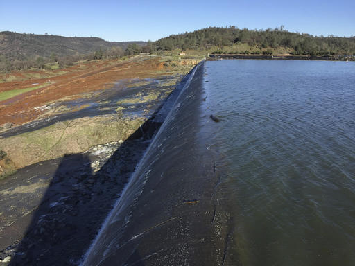
OROVILLE, Calif. (AP) — The water level dropped Monday behind the nation’s tallest dam, reducing the risk of a catastrophic spillway collapse and easing fears that prompted the evacuation of nearly 200,000 people downstream.
As the day began, officials from the California Department of Water Resources officials prepared to inspect an erosion scar on the spillway at the dam on Lake Oroville, about 150 miles northeast of San Francisco.
Authorities ordered evacuations Sunday for everyone living below the lake out of concern that the spillway could fail and send a 30-foot wall of water roaring downstream.
“We grabbed our dog and headed to higher ground — away from the river,” said Kimberly Cumings, who moved with her husband, Patrick, and 3-year-old daughter to Oroville from Fresno a month ago for a new job. They were eating at a restaurant when the evacuation order came.
A driver with a large vehicle and three children of her own gave them a ride to the Red Cross evacuation center at the Silver Dollar Fairgrounds in Chico.
“You can’t take a chance with the baby,” Patrick Cumings said of their decision to flee.
The water level in Lake Oroville rose significantly in recent weeks after a series of storms that dumped rain and snow across California, particularly in northern parts of the state. The high water forced the use of the dam’s emergency spillway, or overflow, for the first time in the dam’s nearly 50-year history on Saturday.
The threat appeared to ease somewhat Monday as the water level dropped. Officials said water was flowing out of the lake at nearly twice the rate as water flowing into it.
Sunday afternoon’s evacuation order came after engineers spotted a hole on the concrete lip of the secondary spillway for the 770-foot-tall Oroville Dam and told authorities that it could fail within the hour.
With more rain expected Wednesday and Thursday, officials were rushing to try to fix the damage and hoping to reduce the dam’s water level by 50 feet ahead of the storms.
The sudden evacuation panicked residents, who scrambled to get their belongings into cars and then grew angry as they sat in bumper-to-bumper traffic hours after the evacuation order was given.
Raj Gill, managing a Shell station where anxious motorists got gas and snacks, said his boss told him to close the station and flee himself. But he stayed open to feed a steady line of customers.
“You can’t even move,” he said. “I’m trying to get out of here too. I’m worried about the flooding. I’ve seen the pictures — that’s a lot of water.”
A Red Cross spokeswoman said more than 500 people showed up at an evacuation center in Chico, California.
The shelter ran out of blankets and cots, and a tractor-trailer with 1,000 more cots was stuck in the gridlock of traffic fleeing the potential flooding Sunday night, Red Cross shelter manager Pam Deditch said.
A California Highway Patrol spokesman said two planes would fly Monday to help with traffic control and possible search-and-rescue missions.
At least 250 California law enforcement officers were posted near the dam and along evacuation routes to manage the exodus and ensure evacuated towns don’t become targets for looting or other criminal activity.
Butte County Sheriff Kory Honea said a lot was still unknown.
“We need to continue to lower the lake levels, and we need to give the Department of Water Resources time to fully evaluate the situation so we can make the decision to whether or not it is safe to repopulate the area,” Honea said.
About 188,000 residents of Yuba, Sutter and Butte counties were ordered to evacuate.
Acting Director Department of Water Resources Bill Croyle said officials will be able to assess the damage to the emergency spillway now that the lake level has come down.
The erosion at the head of the emergency spillway threatens to undermine the concrete weir and allow large, uncontrolled releases of water from Lake Oroville. Those flows could overwhelm the Feather River and other downstream waterways and levees and flood towns in three counties.
Department engineer and spokesman Kevin Dossey told the Sacramento Bee the emergency spillway was rated to handle 250,000 cubic feet per second, but it began to show weakness Sunday after flows peaked at 12,600 cubic feet per second.
The California National Guard notified all its 23,000 soldiers and airmen to be ready to deploy, the first time an alert for the entire California National Guard had been issued since the 1992 riots in Los Angeles after a jury acquitted four police officers in the beating of Rodney King.
The sudden decision Sunday to evacuate tens of thousands of people was a departure from earlier assurances, when officials had stressed the Oroville Dam itself was structurally sound.
Unexpected erosion chewed through the main spillway during heavy rain earlier this week, sending chunks of concrete flying and creating a 200-foot-long, 30-foot-deep hole that continues growing.
Officials are most concerned about the dam’s emergency, earthen spillway that began taking on water after water was diverted from the main concrete spillway because of the damage.
Engineers do not know what caused the cave-in. Chris Orrock, a Department of Water Resources spokesman, said it appears the dam’s main spillway has stopped crumbling even though it is being used for water releases.
The lake is a central piece of California’s government-run water delivery network, supplying water for the state’s Central Valley agricultural heartland and residents and businesses in Southern California.
___
Rodriguez reported from San Francisco. Associated Press Writer Kristin J. Bender contributed to this report from San Francisco.
Copyright 2017 The Associated Press. All rights reserved. This material may not be published, broadcast, rewritten or redistributed.


Some perspective:
Typical waterflow (at least in recent years) in the Feather River below Oroville Dam is less than 10,000 CFM. This is all the water sent through the dam for power generation, fish hatchery support, irrigation, etc.
http://cdec.water.ca.gov/jspplot/jspPlotServlet.jsp?sensor_no=662&end=02%2F13%2F2017+08%3A43&geom=huge&interval=60&cookies=CDEC01
The main spillway - the narrow channel to the left of the dam in the picture below - as of late last night was running at 100,000 CFM. It has the capacity to run 250,000 CFM, though of course it’s got a huge gaping hole in it right now (and probably much bigger now than in this image, which was taken before last night’s emergency. The spillway is 200’ wide so approximately a 20-lane freeway.
The “emergency” spillway is a non-adjustable concrete weir farther to the left of the main spillway. Actually two different weirs, but basically it’s the “lip of the bathtub”. When water gets that high, it’s going over the emergency spillway. There is no decision at that point. From what I could find, the emergency spillway was running at no more than 12,500 CFM yesterday when it started to erode. It is supposed to handle, I think, around 80,000 CFM
The emergency spillway holds back about 30’ of Lake Oroville’s total depth (which is about 700’ at the dam). If the erosion works backward to the weirs and undermines them, a 30’ wall of water (and trees, boulders, the concrete weirs, the parking lot, etc.) is going down the hillside, and 25 square miles (surface area of Lake Oroville) x 30’ of water is pouring out after it. It would be like sending all of Lake Sonoma or most of Clear Lake down the hillside over the course of a few hours.
It’s called the “emergency” spillway for a reason.
Oh, fun fact: there is enough material in the Oroville Dam to build a 2-lane highway around the Earth. I did not know that.
It will be interesting to see if Trump get any help going their way soon or will he be as inept as Bush was with NO. God there is so much stuff a president needs to do well that I just think Trump is going to fuck up even when he’s not trying to.
FOX: Sir Trump always said there is/was no drought in California. Liberals think only in terms of global warming. Lord Jesus gives us free water. Too much in fact.
Good thing we have the Best Infrastructure Anywhere.
FEMA was quite effective under Obama. Be it tornados in the Midwest or superstorms Irene and Sandy they were on the ground. I can attest to this first hand in the NYC area.