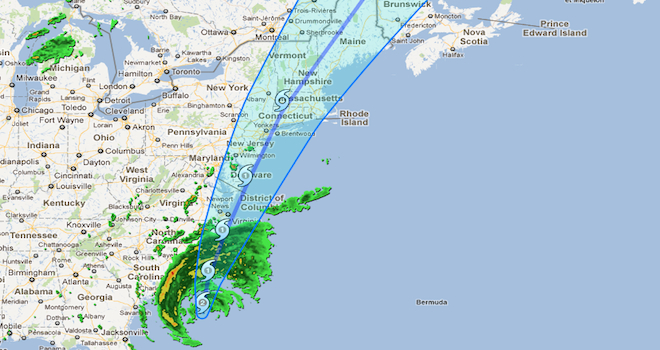
Quick, look at this while you still have power. Google has whipped up a Hurricane Irene tracker in Google Maps.
The tracker contains several additional, customizable layers of useful data aside from the path of the hurricane itself, including weather radar, cloud imagery, evacuation routes from the Highway Safety Improvement Program, storm surge probabilities, among others.
The app came from the furious fingers of Google’s Crisis Response Team, a part of Google’s charity, Google.org. The Crisis Response team has created web tools for victims, loved ones and emergency respondents going back to Cyclone Nagris in 2008.
Earlier this year they launched tools for the Japanese earthquake and tsunami in March and the Christchurch, New Zealand earthquake in February.
But the Hurricane Irene tracker is especially pertinent, aside from even the onset of the storm itself, given that Google just added a dynamic weather layer over its basic maps functionality on August 18. One critical omission in that product: Hurricane Irene! As of yesterday, it still hadn’t been added to the new image layers.
The new crisis response app should take care of that. Visit it at http://crisislanding.appspot.com. But don’t get stuck staring at it for too long, especially if you’re in the hurricane’s sights and have got more supplies to stock up on.


