NASA on Wednesday released an amazing infrared map of the entire sky — at least as much of the infrared sky as we can see using the best tool that was available for the job: NASA’s Wide-field Infrared Survey Explorer (WISE), an unmanned satellite orbiting the Earth that was launched in 2009 and completed its surveying in February 2011.
It took scientists another year and change to sort through WISE’s data — some 2.7 million images, each one snapped every 11 seconds — and put together the incredible map of the infrared sky.
“This data release completes our fundamental objective for WISE: to provide a sensitive infrared all sky survey,” wrote Peter Eisenhardt, WISE’s project scientist, in an email to TPM.
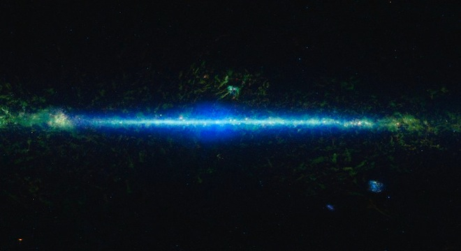
Specifically, the all-sky map includes 18,000 of the most representative images snapped by WISE and stitched together into a single, high-res image showing three of the four wavelengths of infrared light that WISE was able to detect. See the image in various resolutions, zoomable, and with annotated features of the known Universe here at the official WISE website.

“The blue line down the center of the image is the inner Milky Way,” said Edward “Ned” Wright, WISE’s principal investigator and a UCLA astronomer, “The blue color shows stars. Even old red stars show up as blue to WISE.”
“The two blue blotches in the lower right are the Magellanic Clouds, two near neighbors of the Milky Way,” Wright continued. “In the lower left you can see the Andromeda galaxy as a small blue blotch.”
WISE’s infrared vision was key to discovering previously unseen objects in the universe, such as “Y-dwards,” the coolest-temperature class of stars that were theorized but couldn’t be located for over a decade until WISE came about, because these stars have cooled off so much since their formations that they don’t emit any visible light.
WISE itself had to be kept extremely cold during its primary mission, -430 degrees fahrenheit, because anything warmer than that would have emitted infrared radiation and washed out out the view of WISE’s camera. The satellite was equipped a chamber of solid hydrogen to keep it frigid and functioning, although that supply ran out in October 2010. The satellite is still orbiting the Earth, but has been switched off for now until another use can be found for it.
The all-sky survey was actually the work of 14 years of labor by Eisenhardt and several other scientists, including WISE principal investigator Wright, who first proposed the project back in 1998. It took another 11 years to develop, build and launch the actual spacecraft, but Wright, Eisenhardt and their colleagues are confident all the time, energy and money (NASA estimated a $320 million investment to build and maintain the satellite) was worth it.
“As a scientist my personal hope is that the image gives the public some sense of what the Universe is like, from an infrared perspective,” Eisenhardt told TPM.
The WISE team also generated a huge all-sky atlas specifically for use by fellow scientists, to allow the discovery of new features of the universe to continue, even though the satellite itself has gone dark.
“Scientists will want to work directly with the calibrated image atlas, and with the source catalog which provides the measured properties of the more than half billion sources found in the images,” Eisenhardt continued. “Many of these sources are new, and for known sources the WISE data will be used to discover new properties of, and test ideas about the nature of asteroids, stars, galaxies, and the Universe.”


