

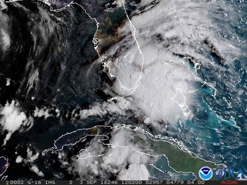
Tropical Storm Gordon lashed South Florida with heavy rains and high winds on Monday, forcing holiday beachgoers to drier ground. Weather forecasters said the storm could strengthen to near-hurricane force by the time it hits the central U.S. Gulf Coast.
Gordon formed into a tropical storm near the Florida Keys early Monday as it moved west-northwest at 16 mph (26 kph). The storm was expected to reach coastal Mississippi and Louisiana by late Tuesday and move inland over the lower Mississippi Valley on Wednesday.
The National Hurricane Center in Miami said at 11 a.m. EDT that the storm was centered 60 miles (95 kilometers) west-northwest of Key Largo and 50 miles (80 kilometers) south-southeast of Marco Island midday Monday. Maximum sustained winds were clocked at 45 mph (75 kph).
Miami Beach Police said via Twitter that the Labor Day holiday was “NOT a beach day,” with rough surf and potential rip currents. Red flags flew over Pensacola-area beaches in Florida’s Panhandle, where swimming and wading in the Gulf of Mexico was prohibited.
The National Weather Service said current conditions were “somewhat favorable” for tornadoes in affected parts of South Florida on Monday.
A hurricane watch – meaning that hurricane conditions are possible – was put into effect for the area stretching from the mouth of the Pearl River in Mississippi to the Alabama-Florida border.
The Miami-based center said the storm is also expected to bring “life-threatening” storm surge to portions of the central Gulf Coast. A storm surge warning has been issued for the area stretching from Shell Beach, Louisiana, to the Mississippi-Alabama. The warning means there is danger of life-threatening inundation. The region could see rising waters of 3 to 5 feet.
“The deepest water will occur along the immediate coast near and to the east of the landfall location, where the surge will be accompanied by large waves,” the center said.
Separately, Tropical Storm Florence continues to hold steady over the eastern Atlantic. Forecasters say little change in strength is expected in coming days and no coastal watches or warnings are in effect.






Have no fear, Trumpistas. Former NY Yankees prospect (according to him) Cadet Bone Spurs will be there toot sweet to toss out the first paper towels.
While I hope all in Gordon’s path can and do prepare to stay safe, I’d like to raise awareness about the significant flooding in parts of Wisconsin. It’s been raining for most of the last 10 days in places like La Crosse and Madison. Some locations have had over 10 inches.
Parts of northern Illinois have also been hit. Two rivers near-ish to me have reached flood stage and it’s still raining.
Why do we even have a waste of taxpayer dollars like the national weather service? This should be privatized and run like a business. Only subscribers can find out what’s coming. Maybe Scott Pruitt could take over and run it right.
please oh please oh please let the waves flood in and ruin mar a lago’s golf course