A 3D simulation video from NASA gives viewers an amazingly close view of a gigantic glacier breaking apart off the western edge of Antartica.
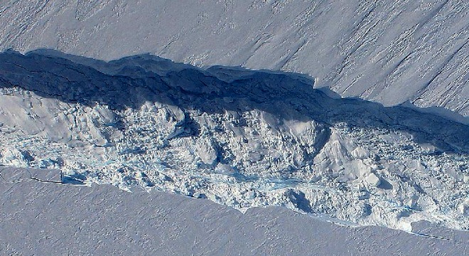
The video takes users on a breathtaking flight through the over 18-mile-long crack in the Pine Island Glacier, which will cause the glacier to break apart in a matter of months, producing an iceberg almost as large as the state of Rhode Island.
The video was generated from elevation models captured during a flyby of the glacier in October 2011, when the crack was first discovered, surprising NASA scientists. The team who made the discovery used a heavily modified Boeing DC-8 aircraft turned aerial laboratory to gather the necessary measurements, part of what was dubbed “Operation IceBridge.”
Check it out here via LiveScience:
After the crack’s discovery in October, NASA got an even more expansive photo of the damage using its Terra AM earth-observing satellite. Scientists determined the crack is 260 feet wide and 195 feet deep, almost down to sea level, and it’s only growing.
Scientists aren’t sure of the precise cause of the crack, but believe it is related to the rapidly thinning ice of the Pine Island Glacier, itself thought to be caused by warm water melting the undersides of the glacier’s edges. As more ice melts and breaks apart, scientists are concerned about the effect the process will have on sea levels worldwide, especially in coastal regions, where they could cause “slow motion flooding.”
Here’s an approximation of the size of the glacier crack:

Chart by Clayton Ashley


