


As Americans stampede to malls and stores this Thanksgiving Day weekend, another, more underground, but no less frenetic pursuit is underway, with participants going so far as to take caffeine pills to stay awake for up to 24 hours.
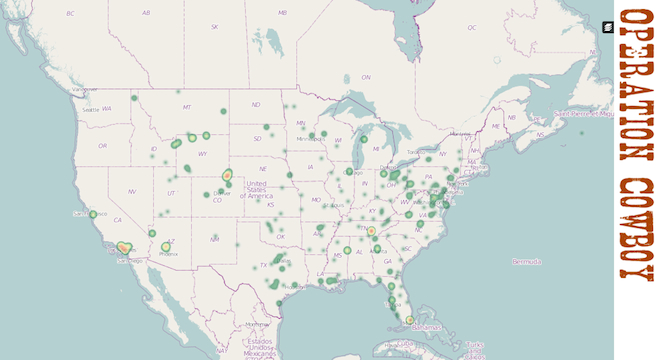
The event, “Operation Cowboy,” is designed to improve the U.S. coverage of OpenStreetMap, a free, crowdsourced alternative to Google Maps.
“The U.S. is a very big place,” said Martijn van Exel, president of the nonprofit OpenStreetMap Foundation’s U.S. chapter, in a phone interview with TPM from his home in Salt Lake City, Utah. “There are lots of places that still go unnoticed and lots of places that go untended [in OpenStreetMap].”
Specifically, the main issue with the OpenStreetMap in the United States is that much of the original roads came from importing the U.S. Census Bureau’s TIGER (Topologically Integrated Geographic Encoding Resource) data back in 2007.
“The spatial alignment [of roads] is pretty bad,” van Exel explained, referring to the fact that some roads in the TIGER dataset are off by several feet, miles in some cases, from where the roads are actually located in the real world. “A lot of data is out of date. Roads are misclassified. There’s a lot of problems.”
So now, OpenStreetMap contributors from around the world are hosting parties to improve the coverage of specific areas of the United States, namely Florida, Utah, Wyoming, Colorado, Georgia, Tennessee, Maine, Texas and California.
They’re doing this not by going out and surveying in the field, but by engaging in “armchair mapping,” comparing OpenStreetMap to another dataset known to be more accurate: Microsoft’s Bing Maps satellite imagery, which Microsoft has explicitly allowed since 2010, when it hired OpenStreetMap’s founder as an engineer.
“There’s too much to do,” van Exel told TPM. “But a lot of it can be solved by comparing OSM to Bing and TIGER 2012 data.”
Still, the project of tracing new roads into OpenStreetMap for 24 hours straight may require some additional stimulation, so the OSM Wiki advises the following:
How to stay awake?
1. Go to bed early the day before or get a nap during the day
2. Get more people going to your party. More people. More partying. Less sleep!
3. Have a chill out corner to get at least some rest for your brains
4. Caffeine of all kinds (coffee, cola, clubmate, pills, …)
5. Fresh air, progressive music, …
OSM’s U.S. president van Exel said he wasn’t worried about map quality declining as the event wears on.
“There’s going to be a few people who stay awake for 23 and 24 hours,” van Exel acknowledged to TPM. “They may make a few mistakes along the way. But they’re going to be fixing many more things that they break.”
Further, van Exel pointed out to TPM that there’s not any obligation to map for any length of time, per se.
“OSM consists of a lot of different types of mappers,” Van Exel said. “There’s a lot of fun to be had in contributing on all levels. People start on armchair stuff, but as they get engaged, a percentage will be interested enough to get GPS and take notebook and camera out there and do actual mapping from the field. Events like these can be a springboard to more engagement.”
Since it was first launched in the United Kingdon in 2004, OpenStreetMap has now gathered 900,000 volunteer contributors around the globe. It’s recently become the go-to choice of some map data for such large tech brands as Apple, Foursquare, Craigslist and Wikipedia. But the increased attention of those commercial entities and others have caused soul-searching within the OSM community as to how to handle for-profit use of a volunteer-made data set.