


Updated 4:54 p.m. EST, Thursday, January 31
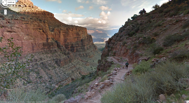
Google’s views of the world are getting more complete, with the company publishing new Street View imagery of the Grand Canyon on Thursday.
There is more utility to the breathtaking views than meets the eye, as Google Maps product manager Ryan Falor wrote in an official blog post on Thursday.
“These beautiful, interactive images cover more than 75 miles of trails and surrounding roads, making our map of this area even more comprehensive, accurate and easy to use than ever before,” Falor wrote.
But users planning on using the new imagery as hiking guides should do so before embarking on their trips and not plan on having access to the Street View panoramas while en route, as cell service is for now spotty at best throughout the area, the U.S. National Park Service warns on its Grand Canyon FAQ webpage:
“Cell phone service throughout much of Northern Arizona is difficult to maintain. It is nearly impossible to get and keep a signal at Grand Canyon, Marble Canyon, Arizona Strip, and area tribal lands. Satellite phones are being tested with some success in places outside of the narrowest portions of the canyon.”
Still, for those who just want to enjoy the natural beauty from the safety and comfort of their desktops, the Google Street View Grand Canyon imagery is about as close as one can come to actually being there. The company published the following video ad promoting the new Street Views. Watch it on YouTube and below:
The imagery was captured not using Google’s traditional Street View camera-equipped cars, of course (which wouldn’t be allowed in the areas of the canyon Google has captured in its new batch of imagery, even if technically outfitted to handle the terrain), but using a relatively new Street View imaging tool called Trekker — essentially a large (30 pound) hiking backpack outfitted with a tower of cameras, first unveiled in the summer of 2012. Here’s a video Google released then promoting the new equipment:
Google’s Trekker uses 15 lenses angled in various directions, which snap photos every 2.5 seconds. The Grand Canyon was the first place Google used the device, the company noted.
And here’s a photo of a Google Street View technician wearing the backpack in front of the Grand Canyon:

Check out all of the Google Street View capture tools, which include everything from trolleys to snowmobiles, here.
Google’s Grand Canyon Street View imagery adds to the Internet giant’s growing collection of panoramic views of the world, which now contains everything from the inside of the White House to Antarctica to under the ocean by Australia’s Great Barrier Reef.
(H/T: Boing Boing.)
Updated to add Google’s video ad promoting the new Grand Canyon Street View image collection.