The Arctic had a record year in 2012 — and not in a good way.
The region, located above the Arctic Circle, or 66 degrees north latitude, suffered record low snow cover and sea ice, while at the same time seeing warmer-than-average sea temperatures, increased green space and vegetation growing seasons, and a boom in Sun-driven plankton production, according to an annual report card from the U.S. National Oceanic and Atmospheric Administration (NOAA), released online Wednesday.
“The Arctic is changing in both predictable and unpredictable ways, so we must expect surprises,” said Jane Lubchenco, Ph.D., under secretary of commerce for oceans and atmosphere and NOAA administrator, in a statement at the American Geophysical Union in San Francisco. “The Arctic is an extremely sensitive part of the world and with the warming scientists have observed, we see the results with less snow and sea ice, greater ice sheet melt and changing vegetation.”
As a consequence of the changes, the Arctic fox is close to extinction in Northern Europe, NOAA said.
One of the most dramatic examples of the record year of losses that the Arctic saw in 2012 was the nearly complete surface melt of the Greenland ice sheet over a stunningly quick 10 days in July, illustrated in the following NOAA graphic:

As NOAA explained: “The unusual melting event followed several months during which high pressure systems repeatedly parked over Greenland. High pressure generally leads to calm winds and sunny skies, both of which boost temperatures during the all-day sunshine of mid-summer at high latitudes. ”
Meanwhile, across the entire region, snow cover fell to a new record low in June. The following NOAA graphic illustrates in brown those regions that saw more snow loss than over the entire 1971-2000 period:

NOAA noted that the snow cover loss was the third record low for North America in five years and the fifth consecutive record low for Europe and Asia.
Sea ice, too plummeted to its smallest minimum coverage area yet — 1.3 million square miles — or 18 percent below the prior record low of 1.65 million square miles in 2007. See the drop-off illustrated in the following graphic, with sea ice area in 2012 compared to the previous record low in yellow and the seasonal average from 1979-2000 in black:

Though sea ice naturally builds-up over the winter and melts during the summer, NOAA noted that the melting trend was clearly becoming more dramatic: All of the last six years have seen the smallest sea ice area since measurements began in 1979.
Meanwhile, the thinner sea ice has allowed more sunlight to stream into the formerly covered, dark Arctic waters, allowing phytoplankton, a plant-based microorganism that uses photosynthesis to fuel itself, to enjoy a population boom. Phytoplankton may extend up to 62 miles below the ice pack in the Chukchi Sea off Northwest Alaska, NOAA explained.
Here are NOAA published on Wednesday showing views from below the Arctic sea line before and after the phytoplankton boom:

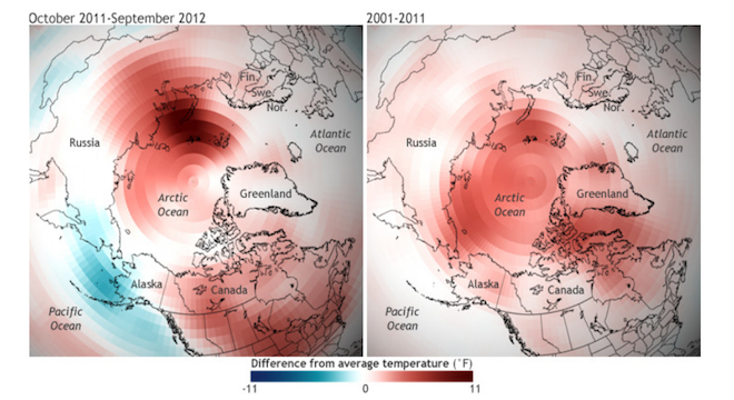
Perhaps most worrisome of all, NOAA noted that the changes were occurring faster than predicted and that the Arctic is entering a “new state” of ice and snow loss.
The agency also published a video highlighting some of the findings of the report card, which was prepared by 141 authors in 15 countries:
As NOAA concluded in a slide presentation on the findings: “Global warming is amplified in Arctic.” See all the key NOAA graphics here.


